Contacts

NAI Parsons Commercial Group - Boston
Property Details
- Property Type VacantLand
- Lot Size 0.77 Acre
- Property Tenancy Multi-Tenant
- Date Updated Feb 20, 2025
Reach out to the broker for more info on lease terms and amenities
Highlights
- Phase I Completed, Geotechnical Studies Completed, Traffic Study Completed & Sample Concept Plans & Renderings Available
- Multiple uses allowed including but not limited to retail, office and industrial and more!
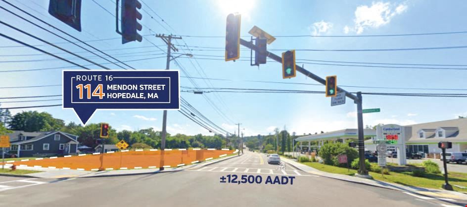
- Highly visible corner lot at a lighted intersection.
- 262'± of frontage on Route 16 (142'± on Hopedale Street).
- Traffic Counts - 12,500 ADT - Projected approximately 1% growth per year, due to the increase in commercial activity, zoning changes and its proximity to medical facilities and new major commercial centers.
- Superior location for any retailer looking to get into an underserved market with strong and increasing demographics.
- The site is prominently located at the entry to the Route 16 central mass corridor.
- The property is located half mile from Milford Regional Medical Center and the Dana Farber/Brigham & Women's Cancer Center.
- Area amenities include: Mendon Twin Drive, Southwick’s Zoo and more.
- Situated 40 miles west of Boston, 25 miles east of Worcester and 30 miles north of Providence, Rhode Island.
Attachments
Getting around
-
50/100
Walk Score ®
-
28/100
Bike Score ®
Location
- City Hopedale, MA
- Neighborhood Hopedale
- Zip Code 01747
- Market Worcester Springfield
Points of Interest
-
Forge Park/495
5.62 miles
-
Southborough
9.76 miles
-
Cumberland Farms
0.04 miles
-
Sunoco
1.02 miles
-
Gulf
1.11 miles
-
Citgo
2.07 miles
-
Canaan Fuels
2.70 miles
-
Rapid Refill
5.21 miles
-
Speedway
5.56 miles
-
BJ
5.75 miles
-
Mobil
5.85 miles
-
Clipper Creek
6.27 miles
-
Upper Charles Trail parking
2.82 miles
-
Weston Pond Parking
4.82 miles
-
College Rock Parking
5.15 miles
-
Pleasure Point
7.18 miles
-
Cameron Woods Trailhead Parking
7.26 miles
-
Weigh Station SR 146 (North Bound)
7.46 miles
-
Rest Area SR 146 (South Bound)
7.54 miles
-
MBTA Parking
7.81 miles
-
Adams School Parking
8.00 miles
-
Placentino School Parking
8.11 miles
-
Fairfield Inn & Suites
2.91 miles
-
Comfort Inn
3.04 miles
-
DoubleTree
3.07 miles
-
Residence Inn Boston Franklin
5.79 miles
-
Home2 Suites
8.27 miles
-
Hampton Inn
8.31 miles
-
Best Western Plus Executive Residency Franklin
8.45 miles
-
Grafton Inn
9.39 miles
-
Shaw's
0.90 miles
-
Big Lots
1.08 miles
-
Big Y
2.32 miles
-
Quarry Square Shopping Center
2.58 miles
-
ALDI
2.60 miles
-
Kohl's
2.78 miles
-
Marshalls
3.00 miles
-
TJ Maxx
3.01 miles
-
Stop & Shop
3.05 miles
-
Target
3.10 miles
Access more in-depth information about this property — including ownership, tenant details, property characteristics and transaction history, along with local market insights and much more — on CommercialEdge.

NAI Parsons Commercial Group - Boston
